
Iceland is a unique destination, famous for its dramatic landscapes, breathtaking Iceland waterfalls, and relaxing natural hot springs. Yet one of the most fascinating things about this island is its geology. Sitting directly on the Mid-Atlantic Ridge, Iceland lies where the North American and Eurasian tectonic plates meet and slowly drift apart. This makes it one of the few places in the world where you can actually see the effects of plate tectonics above the Earth’s surface.
In this travel guide, we’ll answer common questions like what continent is Iceland in and where to see the Iceland tectonic plates. Whether you’re a geology lover or simply curious about nature’s raw power, Iceland’s shifting landscapes offer an unforgettable experience for every traveler.
- Related links: Rent a Car in Iceland; More about Icelandic Nature
Table of Contents
- What Continent is Iceland In?
- Iceland’s Tectonic Plates Explained
- Where to See Tectonic Plates in Iceland?
- Safe Travel Tips
- Frequently Asked Questions

What Continent is Iceland In?
The question what continent is Iceland in has both a geological and a cultural answer.
Geographically, Iceland sits directly on the Mid-Atlantic Ridge, where the North American and Eurasian tectonic plates meet. The western region lies on the North American plate, while the eastern region lies on the Eurasian plate.
Culturally, politically, and historically, Iceland is part of Europe. It is one of the Nordic nations alongside Norway, Sweden, Denmark, and Finland. Although it is not a member of the European Union, Iceland participates in the European Economic Area (EEA) and the Schengen Zone, allowing its citizens to live and work freely throughout Europe.
Iceland was under Danish rule until it became an independent republic in 1944, and it remains closely tied to European institutions and values.
Is Iceland Part of North America?
Technically, part of it is. The North American tectonic plate extends beneath western Iceland, including the Reykjanes Peninsula and Thingvellir National Park. That means when you walk through these areas, you are physically standing on North American ground while still in Iceland.
Because the island straddles two plates, you can drive from an area resting on the North American side to an area resting on the Eurasian side in a single day. This makes Iceland one of the easiest places in the world to experience a plate boundary without any technical hiking or expedition logistics.
A Bridge Between Continents
While Iceland sits on two continents geologically, its cultural identity belongs to Europe. The Icelandic language, governance, architecture, and traditions are deeply rooted in Nordic culture. At the same time, the country’s location between North America and Europe has given it a modern, globally connected character.
Icelanders often describe their nation as a bridge between continents, reflecting its unique blend of European culture and North Atlantic geography. When you visit, you’ll feel this in everything from flight connections and international festivals to the way locals talk about both Europe and North America as their neighbours across the ocean.

Iceland’s Tectonic Plates Explained
Earth’s surface is made up of huge slabs of rock called tectonic plates. These plates float on a layer of molten material in the Earth’s mantle and move slowly over time. Where they meet or separate, they cause earthquakes, volcanoes, and other powerful geological activity.
Iceland’s Unique Location on the Mid-Atlantic Ridge
Iceland is one of the few places on Earth where the meeting point of tectonic plates is visible above ground. It sits directly on the Mid-Atlantic Ridge, the boundary between the North American and Eurasian plates. This location explains the volume of Iceland volancoes and its abundance of hot springs, geysers, and geothermal areas.
Around 60 million years ago, the plates began to drift apart. Magma from deep below the surface rose to fill the gap and cooled into solid rock, creating the foundation of Iceland. This process still continues today, which is why Iceland is often referred to as a geologically young and growing island.
Map tip: If your map or guidebook includes a plate boundary map of Iceland, look for the dark line of the Mid-Atlantic Ridge running from the Reykjanes Peninsula in the southwest through Þingvellir National Park and up towards North Iceland. It helps you visualise exactly where the plates meet as you plan your trip.
Why Iceland Is Splitting Apart
The North American and Eurasian plates are constantly moving away from each other at an average rate of about 2 centimeters per year. As they separate, molten rock rises to fill the space between them, forming new crust. Over thousands of years, this steady motion is what has built Iceland’s wide lava fields, shield volcanoes, and rugged rift valleys.

This divergence does not mean Iceland will split into two separate islands. The rising magma effectively “glues” the country together again each time it moves apart. However, this tension between the plates is what triggers frequent earthquakes, volcanic eruptions, and other geological changes across the island.
The same process powers Iceland’s geothermal energy system, which provides much of the country’s electricity and heating. In short, the same forces that shape Iceland’s landscapes also sustain its modern lifestyle, from cosy heated homes to relaxing outdoor pools in the snow.
Iceland’s Geological Activity in 2025–2026
Recent years have been an especially lively chapter in Iceland’s earthquake and volcano story. Between late 2023 and August 2025, a series of nine eruptions occurred along the Sundhnúkur crater row on the Reykjanes Peninsula, most recently from July 16 to August 5, 2025, with lava flows kept away from towns and main roads. Since then, there has been no ongoing eruption in 2026, but scientists continue to measure ground uplift and magma accumulation beneath the Svartsengi area, meaning the system is still active below the surface.
Earthquake swarms have also affected other parts of the country, including Katla volcano and other southern systems, though most quakes are small and are closely monitored by the Icelandic Meteorological Office. For travellers, this means that life and tourism are continuing as normal, but Iceland’s geology remains very much alive – a reminder that those spectacular rifts, hot springs, and lava fields are the product of an island still in the making
Where to See Tectonic Plates in Iceland?
The Mid-Atlantic ridge cuts diagonally through Iceland from the Southwest to the Northeast of the country. It makes landfall just south of Reykavik Iceland and exits north of Krafla volcano, near Husavik. If you’re visiting Iceland and doing a self-drive roadtrip with a rental car there are three main places you can see the tectonic plates in Iceland.
For most visitors, the easiest way to experience the Iceland plate boundary is to stick to well-developed sites with good parking, marked paths, and clear viewpoints. Þingvellir National Park, the Silfra fissure, and the Reykjanes Peninsula all offer accessible rift valleys, visible fissures, and even the chance to snorkel right where the continents pull apart. If you have more time, heading east to Vatnajökull National Park lets you see how glaciers, volcanoes, and the Mid‑Atlantic Ridge all connect.
Top 3 Ways to Experience Iceland’s Plate Boundary
- Walk the Þingvellir rift valley: Stroll between the cliffs of the North American and Eurasian plates on easy paths.
- Snorkel the Silfra fissure: Float in crystal‑clear water directly in the tectonic rift on a guided tour.
- Cross the Bridge Between Continents on Reykjanes: Walk from the “North American” side to the “Eurasian” side in a few steps, with black lava all around you.

1. Þingvellir National Park
Thingvellir National Park is a UNESCO World Heritage site located about 40 km east of Reykjavik. It is one of the few places on Earth where you can see the Mid-Atlantic Ridge above sea level, where Eurasian and North american plates meet with the clear plate boundaries views. Visitors can hike the Almannagjá gorge, a rift valley where you can literally walk between the continental plates. You may have seen this rift before, as it was featured in Game of Thrones.
There is also a beautiful waterfall in the gorge. Thingvellir National Park is open 24/7 and free to visit. You can also see the site of Alþingi, the supreme national parliament of Iceland that was established 10,000 years ago in the National Park. The park is open year-round and free to enter, although there is a small parking fee of 500 ISK (about 5 USD). Allow at least 30 to 60 minutes to walk through the gorge or a few hours to explore the full area.

From a geology perspective, Þingvellir sits right on the main Iceland plate boundary, and the wide, sunken valley you walk through is part of the Þingvellir National Park tectonic rift. Cracks, rock walls, and small fissures in the lava all show how the crust is stretching and breaking as the plates pull apart. If you enjoy photography, this is one of the best places to capture the feeling of “walking between continents in Iceland”.
You can also experience the divide underwater at Silfra Fissure, a world-famous snorkeling and diving site filled with crystal-clear glacial water. Visibility can exceed 100 meters, and the temperature remains around 2°C year-round. Divers need a drysuit certification, but anyone over 14 can snorkel. A typical Silfra dive lasts 30 to 40 minutes and allows you to literally swim between two continents. You can book a tour to explore Silfra here.
2. Reykjanes Peninsula
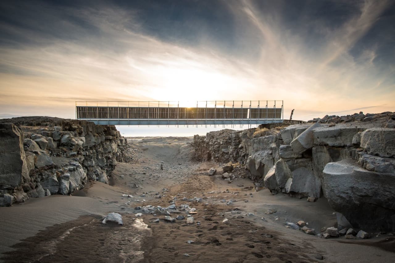
Southwest of Reykjavik, the Reykjanes Peninsula is another striking place to see the tectonic divide. The Bridge Between Continents, also known as Leif the Lucky’s Bridge, is a small footbridge spanning a visible fissure between the North American and Eurasian plates.
After walking across the bridge, visitors can stop at the Reykjanes Information Center to pick up a certificate marking their “crossing” from one continent to the other. The area also features lava fields, geothermal zones in Iceland, and active volcanic systems that showcase Iceland’s dynamic geology. On a clear day you can combine a short walk at the bridge with viewpoints over recent lava fields created by the Reykjanes volcanic activity in 2023–2025.
Because Reykjanes is so close to Keflavík International Airport, it’s perfect for a short road trip either right after you pick up your rental car or on your way back before departure. With a car you can easily link the bridge, coastal cliffs, hot springs, and even the famous Blue Lagoon into one convenient loop.
3. Vatnajökull Glacier
Vatnajökull is the largest glacier in Iceland and covers around 8% of the country. The glacier sits on top of the Grimsvotn volcano, which is located on the Mid-Atlantic Ridge. Visitors can take guided tours of the glacier and see firsthand the impact of the tectonic movements on the landscape. In some areas, you can walk on Iceland black sand beaches that were created by volcanic activity under the glacier.
The contrast here is impressive: on the surface you see bright ice and deep crevasses, but underneath are powerful volcanoes connected to the same plate boundary that runs through Þingvellir and Reykjanes. Many classic Iceland volcanoes and eruptions, including explosive events at Grímsvötn, are tied to this interaction between ice and magma. Joining a guided glacier hike or ice cave tour is one of the safest ways to learn more about this dramatic side of Iceland geology facts while staying on marked routes.

Fun Geology Facts About Iceland
- The North American and Eurasian plates are pulling apart beneath Iceland at roughly 2 centimeters per year, slowly widening the rift valleys you can walk through.
- As the plates diverge, magma rises to fill the gap and cools into basalt rock, which is how new land forms along the Mid-Atlantic Ridge in Iceland.
- Iceland is considered a geologically young island, with most of its surface rocks formed within the last 20 million years – a blink of an eye in Earth’s history.
- Thanks to continuous eruptions and lava flows over time, Iceland gains around 5 centimeters of new land each year, although erosion and glaciers also wear rock away.
- The same plate divergence and magma that create new crust also feed Iceland’s geothermal energy, providing hot water and heating for homes, pools, and greenhouses.
- Iceland has more than 130 volcanic mountains, and many of them are still considered active, which helps explain the country’s frequent earthquakes and hot springs.

Safe Travel Tips for Visiting Iceland’s Tectonic Plates
There are some things to keep in mind that will keep you safe and comfortable during your visit to the tectonic plates in Iceland.
- You must book a tour in advance for any of the activities in Silfra (diving/snorkelling)
- Rent a car early to ensure you have the right vehicle for your route. Find tons of Iceland car rental tips here.
- Be prepared for your trip by planning out your itinerary. The tectonic plates can be visited when driving the Golden Circle in Iceland, or Iceland’s Ring Road.
- Always be aware of the weather in Iceland. It can change very rapidly, and storms can be common, especially during the winter months.
- NEVER try to cross the safety line that’s in place at the attractions. The lines have been strategically put there for the safety of all visitors, so make sure to respect those rules.

FAQs About Iceland’s Continent and Tectonic Plates
Frequently Asked Questions – Iceland Geology and Tectonic Plates
-
-
What continent is Reykjavik in?
Technically, the city of Reykjavik sits on the North American plate, though Iceland is considered part of Europe.
-
What continent is Reykjavik in?
-
-
Can you walk between two tectonic plates in Iceland?
Yes. The best places to do so are Thingvellir National Park and the Bridge Between Continents in Reykjanes, where marked paths lead you along visible rifts.
Pro Tip: The Hertz Iceland Difference – To visit these iconic rifts at your own pace, choosing a rental from our Prime Location inside KEF airport allows you to reach the Bridge Between Continents in just 20 minutes after landing.
-
Can you walk between two tectonic plates in Iceland?
-
-
What tectonic plates meet in Iceland?
Iceland sits on the boundary between the North American and Eurasian tectonic plates, which meet and diverge along the Mid-Atlantic Ridge.
-
What tectonic plates meet in Iceland?
-
-
What tectonic plate is Iceland on?
Iceland straddles both the North American and Eurasian plates, with the main Iceland plate boundary running from the Reykjanes Peninsula through Þingvellir to North Iceland.
-
What tectonic plate is Iceland on?
-
-
Is there a fault line in Iceland?
Yes. The Mid-Atlantic Ridge acts as a major fault line that runs diagonally across the country from Reykjanes in the southwest to Krafla in the north.
-
Is there a fault line in Iceland?
-
-
How deep is Silfra, Iceland?
The fissure reaches about 18 to 20 meters at its deepest point, with exceptional visibility of over 100 meters.
-
How deep is Silfra, Iceland?
-
-
How long does a Silfra dive last?
Typically 30 to 40 minutes, depending on the diver and conditions.
-
How long does a Silfra dive last?
-
-
How often do earthquakes occur in Iceland?
Small earthquakes happen every day in Iceland, especially along active rift zones. Most are too weak to feel, and major quakes are rare and monitored carefully by scientists.
Pro Tip: The Hertz Iceland Difference – While most tremors go unnoticed, our Nationwide Support ensures that if regional conditions ever impact travel, our team is just a phone call away to assist you with route changes or safety advice.
-
How often do earthquakes occur in Iceland?
-
-
Where is the best place to see the Mid-Atlantic Ridge in Iceland?
Þingvellir National Park is the most famous place to see the Mid-Atlantic Ridge on land, but the Reykjanes Peninsula and parts of North Iceland also reveal visible rift valleys and fissures.
-
Where is the best place to see the Mid-Atlantic Ridge in Iceland?
-
-
Is Iceland growing due to tectonic activity?
Yes. As the plates pull apart and magma rises to fill the gap, Iceland gains new crust each year, making it a slowly growing island over geological time.
-
Is Iceland growing due to tectonic activity?
-
-
What makes Iceland’s geology unique?
Iceland sits on both a plate boundary and a powerful mantle hotspot, combining plate divergence, frequent eruptions, geothermal energy, glaciers, and oceanic climate in one compact island.
Pro Tip: The Hertz Iceland Difference – Exploring these rugged landscapes requires a vehicle you can trust. Our Newer, Reliable Fleet consists of vehicles under 2 years old, designed to provide the safety and performance needed for Iceland’s unique terrain.
-
What makes Iceland’s geology unique?
-
-
What language do they speak in Iceland?
The official language is Icelandic, but most locals also speak English fluently.
-
What language do they speak in Iceland?
-
-
Is Iceland part of the United States?
No. Iceland is a sovereign European nation with strong ties to other Nordic countries.
-
Is Iceland part of the United States?
-
-
Can you see North America from Iceland?
No, you cannot see the North American continent from Iceland with the naked eye. However, the North American tectonic plate extends beneath parts of western Iceland, including areas like Reykjanes Peninsula and Thingvellir National Park. When you visit these regions, you are quite literally standing on North American ground while still in Iceland.
-
Can you see North America from Iceland?
Iceland: Where Continents Meet
Iceland’s unique geography is a result of its location on the Mid-Atlantic Ridge, where the North American and Eurasian tectonic plates meet and diverge. This unique position answers the question of what continent Iceland is in – geographically between two, but culturally and politically part of Europe.
The tension created by the movement of these tectonic plates leads to frequent earthquakes and Iceland volcanic activity, which has resulted in the formation of Iceland’s stunning landscapes, including mountains, lava fields, and geothermal areas. Learning a few Iceland geology facts as you travel helps you appreciate why the island looks so different from mainland Europe or North America.
This is the only place in the world where visitors can see the effects of plate tectonics above ground in as many accessible spots as in Iceland, making it a must-visit destination for geology enthusiasts and travellers seeking an unforgettable experience. The best way to get to the viewing points of the tectonic plates and all of Iceland’s top attractions is via rental car. Make sure you book your rental car online and in advance with Hertz Iceland to ensure you get the perfect Iceland rental car option for your group.


